Caveats: First off, I'm no tablet expert. I use GPS quite a bit but for very specific purposes. I also have a Nokia N810 Internet Tablet, which I love. In fact, I love it so much I realized that if it ever broke, there would be a lot of things that I wouldn't be able to do. I realized that I needed a backup. There's nothing that will directly replace the N810 for me, but I thought this CyberNav Mini might replace some of the functions at least. Besides, it might make a decent cheap GPS to mount on my dual-purpose motorcycle and it will also allow me to explore the Android ecosystem, which I've been curious about. What this means is that I'm biased and my review is going to basically amount to a comparison with the N810. Take what you will from it. Nobody is paying me to do this, not even through the site adverts which, at the present rate, should net me my first $100 check in about 2018.
I'll not bother describing the published spec's as they're easy to find. Here are the points I first noticed:
- It does have a tilt sensor. Actually, the level app I installed needed it switched to 'accelerometer' rather than tilt sensor. The level app seems to work okay, so I'm guessing the resolution isn't that bad. Nothing to compare it to, though, other than real levels. I certainly won't be using it to replace my precision machinist's level. It would be more than enough to hang a shelf with.
- The little cap on the top-right (opposite the power button) that looks like a stylus cap is not a stylus. The first thing I did was rip that off in the hopes that it was... had to glue it back on. Oh well.
- The resistive touch screen really works better with a stylus. The GPS mount comes with a tiny one... I've been using my spare N810. Overall, it seems quite precise. It is not multi-touch.
- The GPS is pretty good. I had to go outside for its very first fix, and that took a few minutes. But, overall, it seems to be reasonably sensitive. Not quite as good as my Garmin Dakota 20, but a lot better than the N810.
- I bought mine from an E-Bay reseller and it came with iGo maps. No idea if that's legit or not, so I'm not going to say exactly who I bought it from, but I appreciate the maps. The iGo app is pretty much a "get me to where I want to go" city navigator. Not much use for the likes of me that want to build custom maps, record tracks, and similar activities. OruxMaps, on the other hand, looks promising.
- Battery life, so far, seems to be about the published 2 hours of playing. With the N810, I can get 3 days standby, 6 hours of play, or about 3 hours of GPS. With the CyberNav, running the GPS doesn't seem to make that big a difference. However, this is still very tentative. I'll know better in a couple of weeks.
- Android, at least version 2.2, is not much to scream about compared to the N810's Maemo (debian Linux) OS. I've still not really got into it that far, but it seems to obfuscate rather than just give me control. Then again, I don't really know how to do anything in Android yet, so this too will have to wait for later reviews.
- The Android Market is both amazing and frustrating. Amazing, because it has many more apps than what is available for the N810. Frustrating, because most of them want internet access so they can deliver advertising. However, eventually I got smart and searched for 'opensource'. That gave about 20 pages of goodness.
That's it for now... stay tuned for part 2 mid February.
If you have any specific questions about it, leave a comment.
Update 1: just answering some comment questions
On my first trip to the woods, I fired up the CyberNav and it took it's sweet time getting a lock while I was walking around. Dense forest cover, stuff that would kill my older Garmins, but easily dealt with by the Dakota 20 I have (had - it died). So, good chip but the small antenna limits it a bit. It did lock; it did work. Overall, I'd say it's not bad. Once it gets a lock it seems quite good, very tenacious.
As for mapping apps:
The installed iGo with vector maps takes a bit of getting used to - drove my wife nuts while we were driving home as she couldn't figure out how to do anything. It does route, and auto-route again when you ignore it's directions. The speaker was loud enough to hear over a quiet stereo and the directions were understandable, unlike the N810 audio helper (my impression of the N810 voice was "kidnap victim in trunk of car with socks stuffed in mouth" - useless). No idea yet how the FM transmitter works, but I suppose that would negate listening to music... or maybe not... it's possible it's smart enough to do both but I'm not holding my breath on that. Android, at least v2.2, seems pretty anti-multitasking. I'll make a point of playing with the FM transmitter before the next review.
I've also been playing with the Orux mapping app. It's tile-based, a lot like the old Ozi Explorer that I used before the Garmin vector map editors got useful, before I started using Google Earth to view my tracks. In fact, I just converted my old Ozi maps into Orux format and uploaded them to the CyberNav. They seem to work quite well. So, now I have topo maps of Vancouver Island. Orux does have the ability to download and cache offline map tiles from a variety of sources, but they limit the download to 250MB per map. That's good for hiking in a park but not so great for off-roading. There is a utility call MOBAC (Mobile Atlas Creator, or something like that) which does allow as many tiles as you want per map, but the current version only supports Open Street Map (OSM). The previous version (1.8.x) supported a lot more sources, Google Maps etc., but they got shut down for license violation. You can still find the 1.8 version if you look for it. I'm using it now, as in right now, to cache from Microsoft Maps. Not sure if it will work yet. In any event, with the tile approach, there will always be a way to get decent maps - it's just a lot of work. Right now, I'm just bouncing around between things. It will take a while to find an effective work-flow for what I want to do. I know that, it's not really a CyberNav issue. Well, it would be nice if I could use the custom Garmin-format maps I've built. Haven't found a way to do that yet. Being a tablet rather than a dedicated GPS, it's entirely possible that this functionality will happen at some point. There are apps out there that do support Garmin vector maps.
One real CyberNav issue is that it is most definitely crashing, or something. It's not mechanical, no amount of twisting or tapping will make it shut down. It does seem to be something about the screen-lock or power-save mode. Very often, when I've left it on, with the USB charger connected or not, when I go to use it again by hitting the power button, the only way to get it out of it's blank-screen mode (the power button is the only button on this thing) it will reboot. It's never actually done this while I'm using it - so it's not an issue I'm fretting about. On vehicle-power while running a mapping app that keeps it awake, I don't see this reboot issue as causing any problems. I could be wrong though. I'll update when I know more.
(mini update: I turned off the screen blank and it ran on the USB charger for a couple of days straight. So, yeah, something to do with the power-save mode. It could be something as stupid as me not knowing the magic Android wakeup spell... it's only got that one button though)
(another mini update: Yeah, the "crashing" is just me being an Android newbee. First, returning from powersave mode involves hitting the power button and then WAITING for it. It takes a second or 2. If you don't wait and hold the power button down, it resets. Also, by design, Android shuts down after a defined period of time in powersave mode, 30 minutes by default with the CyberNav. Thus, it isn't crashing, it's just turning off. Nothing to see here, move along folks.)
Oh, battery life, so far, seems pretty consistent. 2 hours off the charger. That's about it. No idea how much standby time it gets as, as I've noted above, it's always off when I go to use it again. Unlike the N810, it doesn't take that long, or that much power, to boot back up though.
One more thing: the guy I bought it off of (if you can assume a masculine identity with "pumpkin_coolstore") says it's fine to link to his store. Thus, I'll assume the iGo maps are somewhat legit, or he doesn't care. I'm not saying this is the best place to buy but it worked well for me. The guy is very customs-savvy, if you know what I mean. Your results may vary.
Update 2: Sunlight and the Screen
I tried it today: Yay! Sun! ...for a few minutes anyway. Outside, the screen washed out completely in direct sunlight. In a side-by-side comparison between it and the N810, the N810 was clearly better. On the dash, the CyberNav was fine and the map always visible while driving around. On the dash, it also appeared brighter than the N810. Likely, the CyberNav has a stronger backlight but is missing that special something that makes the N810 screen better in direct sunlight. You do get what you pay for.
The screen washout might prove an issue with my plans to mount the CyberNav on my motorcycle. However, it shouldn't be that big a deal to shield it for a moment when necessary. Time will tell.
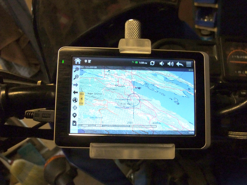
(mini update: Screen glare and washout in sunlight is significant and I nearly gave up trying to figure out how to deal with it. Even a sun-shade wasn't enough to make the map visible while riding. The final answer was, surprisingly, custom high-contrast maps. With those, the maps are visible while riding, even on a sunny day. The sun-shade makes them even better.)
Update 3: Two Weeks In
As a car GPS, unless you need the on-the-fly traffic updates that some dedicated units offer, I'd go with the CyberNav. The GPS is plenty good enough for car stuff, it comes with mounting hardware and power adaptors, and being an Android tablet the mapping options really are amazing. You have choice: see the OSM Mapping Apps list for a start, and that's just the ones that support Open Street Maps. I can't say I'm a fan of iGO, the app my CyberNav came with, but considering the options available I really don't care. I like options. Now, I've never owned or even used one of those dedicated car navigators so please take that into account when reading this review. I'm a back-country GPS user. On the road, well, I managed to circumnavigate North America on a road trip using a world map I got out of a cereal box, seriously. How good does a car GPS have to be?
I don't know how well the CyberNav will operate mounted on the handlebars of my Dual-sport bike, won't really know until spring. However, I've already identified a few mapping apps that look really good, Androzic being one of them as I'm an old OziExplorer users. I dumped my .ozf2 maps into the CyberNav and I'm already set to go, though I will remake these maps with my new routes edited into them. I'm hoping Maperitive will let me do that easily. For those that don't know, the Ozi .ozf2 format does zoom levels very, very well. While Orux supports Ozi maps, it doesn't support the .ozf2 image file format, which is too bad because it's great. Like I said, going with an Android tablet over a dedicated GPS offers a lot of choice, though choice does involve effort and compromise. If you don't like playing and just want directions to a hotel, the extra work might not be worth the effort.
As a walking GPS, I'd say the CyberNav is near useless and even the N810 is a significant improvement. With 2 hours of battery life and not being able to run the GPS while the screen is blanked, you're not going to get very far. If you wanted to mark your position in the parking lot, turn it off, and dump it in your pocket just in case, then it would be okay. It does fire up and find it's location fairly quickly and having that position might prove very, very useful. That's something my N810 fails at miserably as getting a fix can prove an exercise in patience. Then again, it's easy to swap batteries in the N810 and I carry a spare, something the CyberNav just can't do. I've needed that spare battery enough times to realize how much a problem not being able to swap would be. Power is the CyberNav's weakest point. Good in a car, okay to fire up for a quick fix, but if you want the CyberNav to keep the track of your hike, well, you better walk fast. It might be different if there was some secret power-save mode that doesn't reset the CyberNav just to wake up from. If I ever find that, I'll let you know.
Hardware-wise, the CyberNav is nothing to scream at, either way. The resistive screen works very well with a stylus but not so great with fingers. Funny thing was, it came with a shipping protector over the screen and I found fingers weren't that bad. Taking it off actually made finger-swipes harder. If I were a finger-swiping kind of guy, I think I'd be using screen protectors with it just to make the screen a little slipperier. On the other hand, being resistive, I'm hoping I can toss the thing in clear plastic on the bike to keep out the water. Can't do that with capacitive. I doubt fat-finger gloves will get me far so I'll likely have to rig up a stylus holder as well. I have no idea how well the hardware will hold up to the pounding and vibration on the bike. I've already killed 2 Garmin Etrex Legends that way. It's a pretty hostile environment; I don't ride slow and easy. The CyberNav has a much bigger screen and is a whole lot cheaper than the typical hiking GPS units I've used, so I'm willing to see how well it does. The only other hardware issue I've noticed is the CyberNav actually runs a little hot, even when off the USB charger, though it doesn't seem to be a problem. I don't think they worried too much about power management when they designed this thing.
I've done an at-home test with the FM transmitter and it does work. More surprising, Android allows the music player and the iGO app to run at the same time. Thus, it is possible that it will voice-over navigation directions while playing music from the device. I've not actually tried this yet. I'll update when I have. Please don't ask me to rate the audio quality... it's just not my thing. As far as I'm concerned, a car stereo is a device that drowns out the noise from things I haven't got around to fixing yet. A cheesy tablet transmitting FM over the power cable is fine by me.
(mini-update: Yes, it can play music and voice-over navigation from iGO while using the FM transmitter. It actually works quite well. I also found out this thing has a vibrator in it. It buzzes when the battery gets low. I can't think of any use for it, but it's there.)
This last part is more about Android 2.2 than the CyberNav itself. Then again, unless you're going to install something else, Android 2.2 is what you get. First off, I hate on-screen keyboards. The N810 blows the CyberNav out of the water for this very reason. Well, that and the other hardware keys. The lack of any real keys on the CyberNav makes a lot of things oddly difficult. No full-screen button, no zoom in/out, no screen lock. I never realized how useful those buttons were until I didn't have them. Then again, a decent operating system would make the lack of these buttons easier. Android 2.2 is not a decent operating system. Actually entering in text drove me nuts on the CyberNav until I figured out that I could add the Hackers Keyboard that actually had arrow keys. I mean, trying to put the cursor in the exact right position on a 5" screen with no recourse to moving it afterwards was very frustrating. Why anyone would ship a device OS without arrow keys stock? With the Hacker's Keyboard, life is a little easier, but I much prefer working with the N810 in this regard.
The CyberNav comes with a microSD card slot and I happened to have a spare. So, I threw it in. It didn't work, didn't recognize it at all, nothing. No format option either. So, I took it out and re-formatted it in my Linux desktop computer, formatted ext3 (Linux) because I'm that kind of guy. Nothing showed in the CyberNav, again. So, I reformatted it fat32 (DOS) and the CyberNav tried to mount it (mount being a Linux thing) and it just went straight to "safe to remove." That was helpful... I went around in circles for a while until I got the bright idea to format the SD card in an actual Windows machine. It worked fine in the CyberNav after that. So, while Android may have Linux roots, it's lost it's way. I mean, yes, Linux is down there somewhere, but it's buried under something that is not in the spirit of GNU/Linux.
I've used the N810 for several years and I've come to expect certain things from a mobile operating system, and Android doesn't have them. Android 2.2 is a little icky and I don't really like it. Power management is poor, the whole menu system is poor, notifications are poor, it's just clunky and everything -- as in the whole thing -- seems like an afterthought. I can sort of see why: it's designed to allow the screen to rotate, which makes either mode a compromise. It's designed to fit on much smaller screens than the 5" CyberNav, which is a compromise, and, well, it's all a compromise. I mean, on the N810 there's an app you can install that replaces the volume and backlight controls with a single tiny status icon, one that does screen rotation too. Tapping the wireless icon brings up all the wireless controls, like it should. The status bar in Android 2.2 has a bunch of icons that show status but do nothing when you tap them. Why do I have to dig down into the setup menu to find out the battery status? In Maemo, tapping the power status icon says "3 days standby, 7 hours use." You know, something useful. In Android, the volume controls take up half the bar, and then there's this big Media Refresh button, like that's something you need 20 times a day. It's just a big ugly waste of very precious space. I won't even get into multitasking and all the other things that an operating system should do, that Maemo does well and that Android just doesn't. I don't know, maybe the latest version of Android is a lot better. I hope so, because Maemo has been abandoned by Nokia and it's only chance for survival is a dedicated group of volunteer developers, and it blows Android 2.2 out of the water - there's no comparison.
Then, there's the Android Market. No doubt about it, there's an amazing selection of apps there. Finding them is an issue as the whole search function in the market seems designed to irritate the hell out of a person. I mean, who would design a search pane that shows previous searches but doesn't let you edit them before redoing them? What's the point? I search for "mapping" and get way too many hits. So, I hit the search button again and the search box is clear. Below it is a list of previous searches. At that point, you can type your search in again, "mapping vector" for example, or you can hit "mapping" below, and redo your search on mapping. Remember, this is all on a horrible virtual keyboard, no cnrl-c/v. The very notion of having a search box that lets you re-run previous searches without the ability to edit them pretty much sums up Android. It's just not finished, anywhere.
The N810 has a standard set of debian Linux package repositories. If you know Linux, these make perfect sense. They work via GUI or via terminal, like all things Linux. Maemo is Linux, not some obfuscated kernel buried under a half-baked GUI menu. These package repositories have a useful number of applications, mostly ones that have been ported from the standard Linux repositories. However, the choices are very limited in comparison to the Android market. Yes, near any Linux application could be ported to the N810, but it would have to be "hildonized," to work properly. Hildon being the actual desktop interface used by Maemo. This is possible to do but requires quite a skill-set. The result is that the applications that developer-type people want are all in the Maemo repositories, but other things can be scarce. So, yes, there's a certain amount of app-envy going on, even if Maemo is better overall. If I could get an Android emulator for Maemo, I'd re-install the CyberNav straight away; no second thoughts. In part, I bought the CyberNav to see what Android was all about. I've seen... not impressed, but still want the apps so I'll use Android and deal with the lousy market to get them.
Another mini-update: Speaking of apps... the music player that the CyberNav comes with is absurdly frustrating, almost bizarrely frustrating. In the Android Market there are a lot of replacements. I picked "the Android Music Player" from JRTStudio. No idea if that's the best but it sure beats the stock one. Supposedly, it's a back-port of the OpenSource one that came with Honeycome.
Update 4: The Wrap-Up
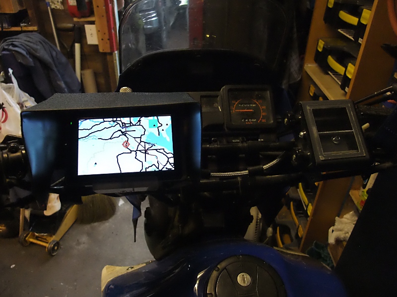
I quite like having the CyberNav mounted on the handlebars of my dualsport motorcycle. It was not without issues in the beginning, but it's great now that I've worked out the kinks.The biggest problem is the screen. At first, it was impossible to see in daylight. Nothing, nadda, just washed out glare. I tried not using any screen protector, I tried a sun screen, and I tried a lot of swearing. I almost gave up on the thing and relegated it to kid-toy status. But, in all my trials, I did notice one odd thing. While I couldn't see anything on the map, I could see the white application border. Ah, I thought, maybe high-contrast maps would help a little. Actually, they helped significantly, much more than expected, and more than enough to make the CyberNav useful in daylight. My kid's not happy that he lost his new toy but I have something I can play with.
Yes, with custom high-contrast mostly black and white maps with nice thick lines for roads and very little other details, the CyberNav screen is readable while mounted on the handlebars. At a glance, I can see the trail I'm on, I can see when the intersections are coming up, and, well, it's great. More than great, really, with that 5" screen it's the best I've ever had for riding.
I'm running it off a dollar-store cig-lighter to USB charger, basically the same as what the CyberNav came with. The intent, someday, is to wire the adapter right into the bike wiring harness, thus I didn't want to cut up the original, but I've not actually got there yet. It's just sitting there taped in place. Works fine.
I've got around 1000km of fairly aggressive trail riding on it and it seems to be holding up well. I fabricated a mount for it using rubber grommets to isolate vibration but I'm not entirely happy with the results - still too much buzzing. So far, the CyberNav has handled that without complaint but I expect there are internal connections that will have issues at some point. I may fab a better mount... maybe for the next tablet.
The screen seems to be holding up well even when being coated with dust then jabbed at and swiped by gloved hands while riding. I figured it would be a mess of scratches by now, what with no screen protector, but it still looks pretty good. I was concerned about using a resistive display rather than the tougher capacitive ones. But, the resistive display means that I don't have to futz around with trying to make conductive fingers on my gloves and it seems to be holding up well enough. My next tablet might just be resistive too.
I've been lucky so far in not having major rain events while riding. For the drizzle and soaked branches I've run into, the sun screen has provided more than adequate coverage. I figure, if it really, really starts to pour... the CyberNav can go in my pocket and I'll head home. I know where home is... don't need a navigator for that one. It's been splashed with mud while crashing through the bush behind other riders in a dualsport event. It's been pounded through the rough sections to the point where I was bottoming my suspension so hard I had to back off. It's lived the life of a dirtbiker, and it's been tough like one too. I am impressed.
The CyberNav can have issues while trying to get a location fix while under heavy tree cover and moving quickly. Being under heavy tree cover and moving quickly is a dirtbiker's natural habitat so that has caused a few missed sections on recorded tracks. Once it has a lock, it generally keeps it. But, there have been a few times where I had to stop in a clearing to let it find it's way. It's better than my old Garmin Etrek Legend was, but not as good as my Dakota 20. It's also cheaper than both by far so I can live with it's current performance.
It has crashed on me while riding a few times. (I've crashed on it a couple of times, so all's fair ) I don't know if it's the hardware, the OS, or the mapping application. I'm running Orux Maps and it's still rather fresh, so I'm not going to scream about stability problems. I've settled on Orux Maps after a lot of searching. Orux is very, very customizable. It is so customizable that, out of the box, it really doesn't come across that good. But, if you dig down and experiment, you can set it up to do amazing things. Stuff like hiding all the controls to give you a full screen of map, with the controls just a tap away. Nice big buttons if you want, or small. Everything seems to be adjustable... I'm even running my very own custom cursor. Orux rocks when you set it up right.
Orux is using a custom set of map tiles I've created from OSM data. That was a huge ordeal to get figured out. Editing OSM data via JOSM, to Maperitive with a custom rule-set to create the tiles, to MOBAC to make the Orux maps. Each program has a significant learning curve and everything has to be right to get what I wanted. However, that is now history. I've got it figured and I can make any kind of map I want with anything on it. I now have the maps I dreamed of while fighting in the Garmin world. All my data, all my regular routes, all the areas I've found on Google Earth and have marked for exploration. They're all there on the CyberNav screen as I crash through overgrown trails others have long forgotten about. That's the whole point of riding with a GPS mounted on the handlebars.
I am completely sold on using an Android tablet as a handlebar mounted GPS. There are issues with cheap hardware, the screen is not what I would prefer, but with the right maps it's more than good enough. It's better than anything I've run before. It's also very cheap. At this point, I don't really care if I kill the CyberNav in a year or so of riding. I'm so happy with the approach that I've already decided I'll be buying a new Android tablet every winter for the next few years. The old ones will get relegated to backup status, and eventually be that toy for my kid. The tablets are improving so fast that a yearly replacement seems the way to go. Rather than paying for the latest and greatest, just keep buying the current cheap model (last year's latest and greatest). If they die on the bike... oh well. If they live, like the CyberNav has, then I'll be even happier than I am now.
Update: Pictures!
Another mini update: Nearly 2015 and the stupid thing is still working. No screen protector, no waterproof cover, mounted on the handlebar of a dirtbike being ridden by a crazy person, sometimes in sanctioned off-road races, in the pouring rain. 3 years of riding... It still works.
And another update... this thing rocks! So, the battery basically died. It would last maybe 5 min on a charge. Normally, I'm running it on my fully off-road dirtbike, powered with a $15 USB battery pack... spec'd at 30,000mah (yeah, right) but it runs the CyberNav for over 5 hours, which is longer than I can last crashing around in the bush. But, every once in a while, the battery pack shuts off, or the connector gets bumped, etc.. It's annoying as the CyberNav then shuts down. I like recording my tracks for later mapping and missing big chunks is annoying. So, I decided to replace the battery. I cracked it open, measured the existing battery, which was quite small, and the space that a battery could fit. Ebay price for a replacement was $20... hmmm... I've actually bought 3 of those 30,000mah battery packs, less than $20 each, and I know they have 4 batteries in them (because I'm the kind of guy that takes things apart for fun): 2 big, 2 small, all in parallel. The big one is exactly the max size that will fit in the CyberNav. Well, you can guess the rest. The CyberNav now runs for well over an hour again. Still works. Screen has a few scratches but nothing serious. Still mounted on the handlebars of my dirtbike... rain, dust, mud, lots of vibration, crashes... stupid thing must have been made by Timex.